2018–2019 Design Alternatives Resources
Logan River – Kunzler Reach – 600 West to 1000 West
Resources
Handouts & Pictures
During our field trip on October 26, 2018, we gave you the following maps:
Google Album
Field Trip Photos
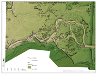
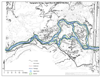
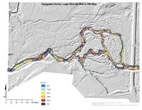
Shaded Relief DEM and Contours
DEM and Contour Maps
Contours Only Map
Contours Only Map
Geomorphic Unit Form Mapping
Geomorphic Unit Form Mapping
See below for Topo and GUT datasets these maps were based on.
Datasets
GIS Data for Students Only
Basemapping - Aerial Photography & Topography
- Logan River Aerial Photos for 1952, 1959, 1966, 1974, 1974, 1977, 1980, 1981, 1987, 1993, 1997, 2004, 2008, 2010, 2011, 2012, 2013 - WARNING! These are large files.
- Utah AGRC Aerial Photography - includes a mix of data you can download as well as WMTS.
- Logan River LiDAR Survey - From City of Logan
- Hybrid 50cm Topo - Merge of 1 m LiDAR w/ 10cm total station bathymetry.
Context
- Logan River Context Layers - A stream network with reaches delineated, and valley bottoms.
- Utah Parcels - for property boundaries
- Wetland Mapping
Reach-Scale Models
- 2016 Geomorphic Change Detection Project - If you download and install GCD addIn this is the easiest way to view the in-channel topographic surveys for the area.
- 2016 August GUT ( Logan River (Golf Course Road to 10th West) GUT 2.2.1 Project) or and GUT LayerFiles
GCD
Geomorphic Change Detection Tool
pyGUT
GUT Tool Documentation
Network Models
- Logan River Watershed BRAT - The Beaver Restoration Assessment Tool outputs for Logan River. - Layer Package only
BRAT
Beaver Restoration Assessment Tool
Condition Assessment Exercises
See Condition Assessment Exercises for BRAT & RCAT data and instructions
Examples of Design Alternatives from Fall 2017
See the slides below to get a feel for what the 2017 class did:
WATS 5340 Topics
← WATS 5340 Topics
Back to Design Alternatives Project
↑ Back to Design Alternatives Project